The weather predictions have been just insane for the past few days.
There is a Colorado low that’s supposed to sweep through in a couple of days, with the worst of the storm happening on Wednesday and Thursday, then petering off on the Friday (it is Monday, as I write this).
When I first started seeing the forecasts, they were saying up to 10cm/4in accumulated snow. That’s over 3 days, so not too bad.
That went up to 20cm/8in.
Then 30cm/12in.
Last night, it went up to a possible 40cm/16in.
This morning, it had changed to up to 50cm/20in in some places!!
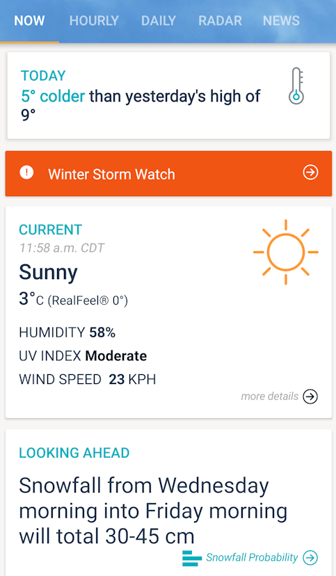
Locally, they’re saying up to 45cm/18in over the three days. I took this screencap just before noon today.
Of course, different apps say different things. The above image is from AccuWeather. This one is from The Weather Network.
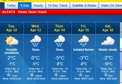
Which forecasts up to about 35cm/14in over the three days.
Both advisories to the Government of Canada alerts, which current reads as follows.
ALERTS IN EFFECT
Winter Storm Watch
Issued at 04:34 Monday 11 April 2022
Major spring blizzard poised to wallop southern Manitoba and southeastern Saskatchewan mid-week…with widespread snowfall accumulations of 30-50 cm accompanied by northerly winds gusting 70-90 km/h giving zero visibility at times in snow and blowing snow.
A Colorado low will move towards Minnesota Tuesday night bringing a heavy swath of snow from southeastern Saskatchewan through most of southern Manitoba. The snow will start early Tuesday evening near the International border then push northward throughout the night. By Wednesday morning heavy snow will be falling in much of the area as the storm continues to push northward, and snow accompanied by strong northerly winds is expected to continue right through to early Friday morning as the low slowly pivots through Minnesota on it’s way into northwestern Ontario. By Friday morning widespread snowfall accumulations of 30 to 50 cm are expected…with possible accumulations approaching 80 cm in the higher terrain of western Manitoba and the western Red River Valley.
Travel will become increasingly difficult as the day progresses Wednesday, with widespread highway closures a near-certainty. By Wednesday evening even travel within communities may become impossible as the heavy snow and strong winds continue… and more of the same is expected on Thursday.
Do not plan to travel – this storm has the potential to be the worst blizzard in decades. Stock up on needed supplies and medications now. Power outages are likely, rural areas in particular should be prepared for extended outages.
Conditions should begin to improve on Friday as the winds taper off and the heaviest snow moves into northern Ontario…although the clean-up after this storm will likely last well into next week.
I bolded some of the text myself, not the site. Yes, they are predicting up to 80cm/32in in some places!!!!
Typically, these weather warnings may suggest that roads might be closed, etc. They don’t usually use terms like “near certainly” for road closures, and they don’t usually say “stock up now” nor include warnings for extended power outages.
Right now, there’s basically nothing at all on the weather radar, over almost all of Canada. Looking at the animated radar forecast, there’s a system making its way quickly, through Nevada, Utah, Idaho and Wyoming. It should hit Montana by this evening. That’s the system that’s heading our way. Sort of.
Here’s the thing.
We aren’t that far South. In fact, we’re far enough North that the storm might miss us entirely.
Or, we’ll get those 45cm/18in.
This?
This is why we work to maintain our supplies for at least a month at a time, while shooting for even longer. This is why we’re working towards having a well with a hand pump. This is why we’re working towards being able to make do without electricity (though we do need at least a way to power my husband’s CPAP so he can sleep! Something we don’t have, yet). If the storm hits as predicted, we likely won’t be able to go anywhere for days.
About all we can do right now is pray that the storm will dissipate and not be as severe as predicted. We can certainly still use more moisture, so some rain or even snow is desirable. Just not a blizzard of this magnitude!
But just in case it doesn’t, we’ll be okay. There are many others we are far more concerned about.
Hmm. My sister just took my mother for her grocery shopping a few days ago. I think maybe I should arrange for another trip for her tomorrow, even though the grocery store is just a couple of blocks away for her.
The Re-Farmer


The opposite problem in Arizona weather reporting. See
:-)
LikeLiked by 1 person
Wow!!
LikeLike
Bless you! I would freeze to death. I love winter but boy am I glad I get 4 full length seasons even with my yellow pollen bomb haze here in Eastern Virginia.
LikeLiked by 1 person
Yeah, we’ve got winter, almost winter, not quite winter, and hot AF (also known as “construction season” in the city).
LikeLiked by 1 person
I feel like the language being used around this storm is inflammatory tho…like we’re supposed to be panicking. Something feels off about it.
A friend told me on FB that we’ve handled worse storms over the winter so we can do this no problem, and she’s right. And those worse storms didn’t come with the same doomsayer style reporting.
Maybe everyone is just burnt out after this winter, but this reporting just feels strange…
LikeLiked by 2 people
You are not the first person I’ve heard this from. Particularly in the timing. It smells off to me, too.
The last two years, the powers that be kept people apart during major holidays with their illegal restrictions and mandates. People are cluing in to the BS and ignoring them, and they can’t just declare another lockdown out of the blue. But a storm is a convenient way to tell people to stay home and away from each other.
LikeLiked by 1 person
Inflammatory language seems to be the norm these days. Stay safe up there. I am so glad you are prepared.
LikeLiked by 2 people
Thanks. :-)
LikeLiked by 2 people